Hyper Sculpture (Iaac GSS/ Tehran)
Iaac Global Summer School at TUIC (Tehran Urban Innovation Center)
Mentors: Helioripple (Amin Bahrami, Hoda Farazandeh, Sonay Servatkhah, Niloufar Najafi) ,TUIC (Nashi Nabian), IaaC (Ramin Shambayati, Mahdi Najafi, Lili Tayefi) , Tehran Platform (Mehran Davari)
The Global Summer School (GSS) is a platform defined by ambitious, multi-scalar investigation on the implications of emergent techniques in our planned environments. Each year, international teams located in key cities around the globe explore a common agenda with projects that are deeply embedded in diverse local conditions. HyperSculptures was defined and developed within a full-time two-week workshop called Global Summer School 2016, an initiative launched by the Institute for Advanced Architecture of Catalonia (Iaac) and implemented alongside a global network of cities. IaaC Global Summer Schools is a full-time two-week course open to creative and innovative people who are interested in fields such as architecture, urban planning, digital fabrication, and design, searching for a multidisciplinary experience in an international environment. The GSS 2016 was directed by IaaC and developed in collaboration with multiple Nodes participating in the course from and in different parts of the globe, including Barcelona, New York City, Moscow, Beirut, Beijing, Monterrey, Mumbai, and Tehran. Because of this, participants have an international laboratory to test their design hypothesis, understanding how design conclusions derived locally can be tested and evolved globally in different cities where other teams reside. This intensive two-week course connects each participant to ongoing research agendas in robotics, simulation, physical computing, parametric design, digital fabrication, and other relevant emerging design methodologies. Specific emphasis is placed on understanding the multiscalar implications of design conclusions, thus creating critical research advanced on applying new technologies in design.
The way we describe and understand cities today is radically changing, and alongside this change, there is also a radical transformation in the tools we use to design them. As a result, cities call for a different approach towards developing new multi-scalar strategies in urban design and planning solutions.
Agenda
The way we describe and understand cities today is radically changing, and alongside this change, there is also a radical transformation in the tools we use to design them. Cities call for a different approach towards developing new multi-scalar strategies in urban design and planning solutions. Networked ecologies embody the dominant form of the organization today: the network, be it telematic, physical, or even social. These generate a complexity that can be organized through technology, laws, political pressures, disciplinary desires, environmental constraints, and social interaction. Cities can be described as systems of networked ecologies: a series of co-dependent aggregations revolving around environmental mitigation, land-use organization, communication, and service delivery. These generate a complexity that can be organized through technology, laws, political pressures, disciplinary desires, environmental constraints, and social interaction. Networked ecologies embody the dominant form of an organization today: the network, be it telematic, physical, or even social. The workshop focused on the potential of this network to work not only at an urban scale but also across diverse cities, interconnecting and expanding them. These will ultimately create a dynamic and interactive system of Hyper Cities: a variety of city-sensors (digital or analog) processing and transferring information in explicit manifestations, interrelating with the collective environment. Understanding the multiple hyper-connected elements, the dynamics of the urban phenomena requires well-designed and sophisticated tools. With the advancements in Do-It-Yourself data collection devices, algorithmic digital modeling tools, and digital fabrication techniques, there seems to be a limitless range of methods to move beyond data visualization, approaching data physicalization.
The project “HyperSculptures” investigated the trilogy of data collection, data analysis, and data visualization/data physicalization, emphasizing the capacities of the digital fabrication methods as an added value. The project’s outcome consisted of three data sculptures: ‘MyCityBit’, ‘Sense-able Memories’, and ‘Voxel City’. IaaC is delighted to develop and launch the ‘Global Summer School 2016’: ‘Hyper Cities’. This year the course will explore cities as systems of networked ecologies: a series of co-dependent aggregations revolving around environmental mitigation, land-use organization, communication, and service delivery. The ‘Global Summer School’ (GSS) is a platform defined by ambitious, multi-scalar investigation on the implications of emergent techniques in our planned environments. Each year, international teams located in key cities around the globe explore a common agenda with projects that are deeply embedded in diverse local conditions. IaaC GSS is a full-time two-week course open to creative and innovative people who are interested in fields such as architecture, urban planning, digital fabrication, and design, searching for a multidisciplinary experience in an international environment. The GSS16 will be directed by IaaC and developed in collaboration with multiple Nodes participating in the course from different parts of the globe, including Barcelona, New York City, Moscow, Beirut, Beijing, Monterrey, Mumbai, and Tehran.
The Projects:
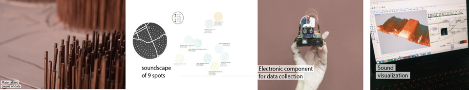
Sensible Memories
The project’s objective was to rethink how a series of collected data can be represented, through digital and physical means, challenging the typical data representation and visualization methods. The students were divided into three groups, collecting data of 9 different spots in the city. Then, on a general map of the whole city, the level and frequency of environmental sounds were materialized with copper rods. The whole installation starts to perform by the time the user touches the copper rods: listening to the environmental sounds of each spot while enjoying the temperature, humidity, and CO2 rate which have been visually projected on the map. These data representations come together to shape the memory of each city spot. The conception of a city as a platform hosts various potential data layers. The installation has been designed and made so its form allows the audience to sense the layers in various manners. In other words, the installation is a kind of combination of both physical and digital interfaces of urban layers.
-
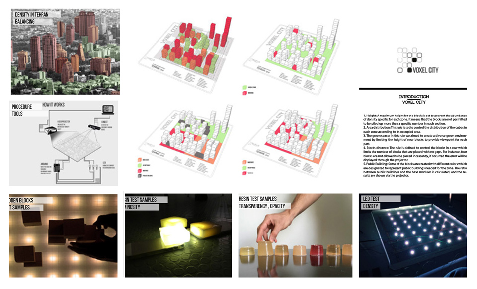
Height: A maximum height for the blocks is set to prevent the abundance of density specific for each zone. It means that the blocks are not permitted to be piled up more than a specific number in each section.
-
Area distribution: This rule is set to control the distribution of the cubes in each zone according to its occupied area.
-
The Green Space: In this rule,laser-cut, we aimed to create a diverse green environment by limiting the height of near blocks to provide viewpoints for each part.
-
Blocks distance: The rule is defined to control the blocks in a nonlimiting number of blocks placed with no gaps. For instance, four blocks are not allowed to be placed incessantly. If occurred, the error will be displayed through the projector.
-
Public Building: Some blocks are created with different colors, designated to represent public buildings needed for the zone. The ratio between public buildings and the base modules is calculated, and the results are shown via the projector.
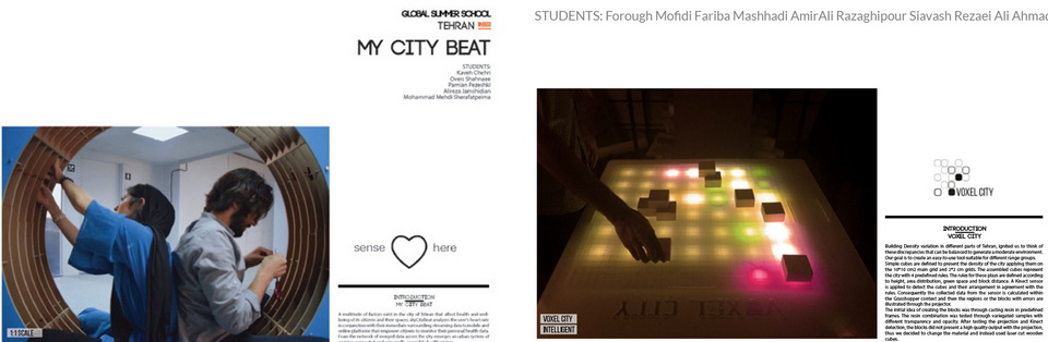
STUDENTS: Forough Mofidi Fariba Mashhadi AmirAli Razaghipour Siavash Rezaei Ali Ahmadian
Voxel City
Building Density variation in different parts of Tehran ignited us to think of these discrepancies that can be balanced to generate a moderate environment. Our goal is to create an easy-to-use tool suitable for different range groups. Simple cubes are defined to present the city’s density, applying them on the 1010 cm2 primary grid and 22 cm grids. The assembled cubes represent the city with four predefined rules. The rules for these plays are defined according to height, area distribution, green space, and block distance. According to the rules, a Kinect sensor is applied to detect the cubes and their arrangement. Consequently, the collected data from the sensor is calculated within the Grasshopper context, and then the regions or the blocks with errors are illustrated through the projector. The initial idea of creating the blocks was casting resin in predefined frames. The resin combination was tested through variegated samples with different transparency and opacity. After testing the projection and Kinect detection, the blocks did not present a high-quality output with the projection. Thus, we changed the material and instead used laser-cut fort wooden cubes.
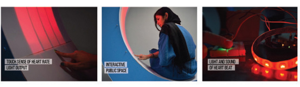
My City Beat
A multitude of factors exists in Tehran’s city that affect the health and well-being of its citizens and their spaces. CityBeat analyzes the user’s heart rate in conjunction with their immediate surroundings, streaming data to mobile and online platforms that empower citizens to monitor their health data. From the network of merged data across the city emerges an urban system of an inter-connected and universally accessible health system. A multitude of factors exists in Tehran’s city that affect the health and well-being of its citizens and their spaces. CityBeat analyzes the user’s heart rate in conjunction with their immediate surroundings, streaming data to mobile and online platforms that empower citizens to monitor their personal health data.